Forecast
Today's Forecast
Friday 7th November
Some of the faulty links have at last been repaired
Rain radar is clear for the SE
Visual and infrared satellite images are showing a lot of low cloud over the SE. The cloud is coming in from the S.
In spite of receiving live visual and infrared satellite pictures every 15 minutes the cloud is still sometimes difficult to predict when and by how much the cloud is going to break up
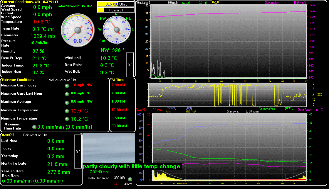
Note. Temperatures are taken at 1.25mtrs above the ground on a north facing wal
Today will remain mild but mostly cloudy with the chance of some patchy drizzle at times. Cloud slowly thinning by around midday to give some brighter / brief sunny spells.
Top temperatures 14.5 to 15.5C
Winds from a SSE / SE / SSE direction will calm to very light at first increasing to light and then light to brisk by early afternoon,
A mostly cloudy, mild evening the chance of some light drizzle in places. Staying dry overnight with clear spells.
Minimum temperatures 12 to 11C,
Winds from a SSE later S / SSW direction will be light to very light
The temperature at 0728GMT was 13.9C previously 13.4C, humidity 92% and the barometric. pressure 1005.8mb's and rising
Top temperature yesterday was 16.9C
Last gust was zero
Rain for January was 68.5mm
Rain for February was 42.2mm
Rain for March was only 3.6mm
Rain for April was 28.8mm
Rain for May was 17.1mm
Rain for June was 27.2mm
Rain for July was 56.8mm
Rain for August was 20.8mm
Rain for September was 42.2mm
Rain for October was 57.1mm
Rain so yesterday was 0.2mm
Rain so far for November is 6.0mm
Rain year to date is 372.4mm
Rain for 2024 was 676.7mm which was above average for this area
Rain for 2023 was 713.4mm which is above average for this area
Rain for 2022 was 572.7mm which is average for this area.
Rain for 2021 was 642.9mm which is slightly above average for this area.
Rain for 2020 was 607.4mm which was about average for this area.
Rain for 2019 was 696.3mm which was above average
Rain for 2018 was 617.8mm which is slightly above average
Rain for 2017 was 707.7mm which is above average for this area.
Rain for 2016 was 586.7mm which is average for this area.
Rain for 2015 was 581.6mm which is average for SW Essex
Rain for 2014 was 881.4mm which is an all time record for this area..
Rain for 2013 was 727.2mm which is above average for SW Essex.
Rain for 2012 was 858.9mm which was high for this area.
Rain for 2011 was 417.5mm which is very low for this area which normally has around 525 to 575mm
Last updated at 0728GMT Friday
Next update at 6.0pm
