Forecast
Tonight's Forecast
Saturday 6th June
Some of the faulty links have at last been repaired
For live lightning click on live data to see the Microsferics, zoomable colour map. If you continue to zoom you will see blue spot with UPM1
Rain radar is showing dry spells with blue patches moving ENE across the SE
Although visual and Infrared satellite images are showing a lot of cloud over the SE there are areas of thinner cloud with some breaks in it. The cloud is coming in from the WSW / SW
.In spite of receiving live visual and infrared satellite pictures every 15 minutes the cloud is still sometimes difficult to predict when and by how much it is going to break up
Note. Temperatures are taken at 1.25mtrs above the ground on a north facing wall
A rather cloudy, mild evening with further outbreaks of rain / Scattered showers. Rain / showers soon clearing to the NE / ENE. The rest of the evening will be dry but mostly cloudy. Staying dry overnight with clear spells / periods.
Minimum temperatures 13 to 12C,
Winds from a WSW / SW / WSW direction will be brisk to strong at times moderating to brisk by dawn.
After a cool start tomorrow will be dry with plenty of bright / sunny spells throughout the day.
Top temperatures slightly higher than today's at around 21.5 to 23.0C
UV and Pollen both HIGH
Winds from a WSW / SW direction will be brisk
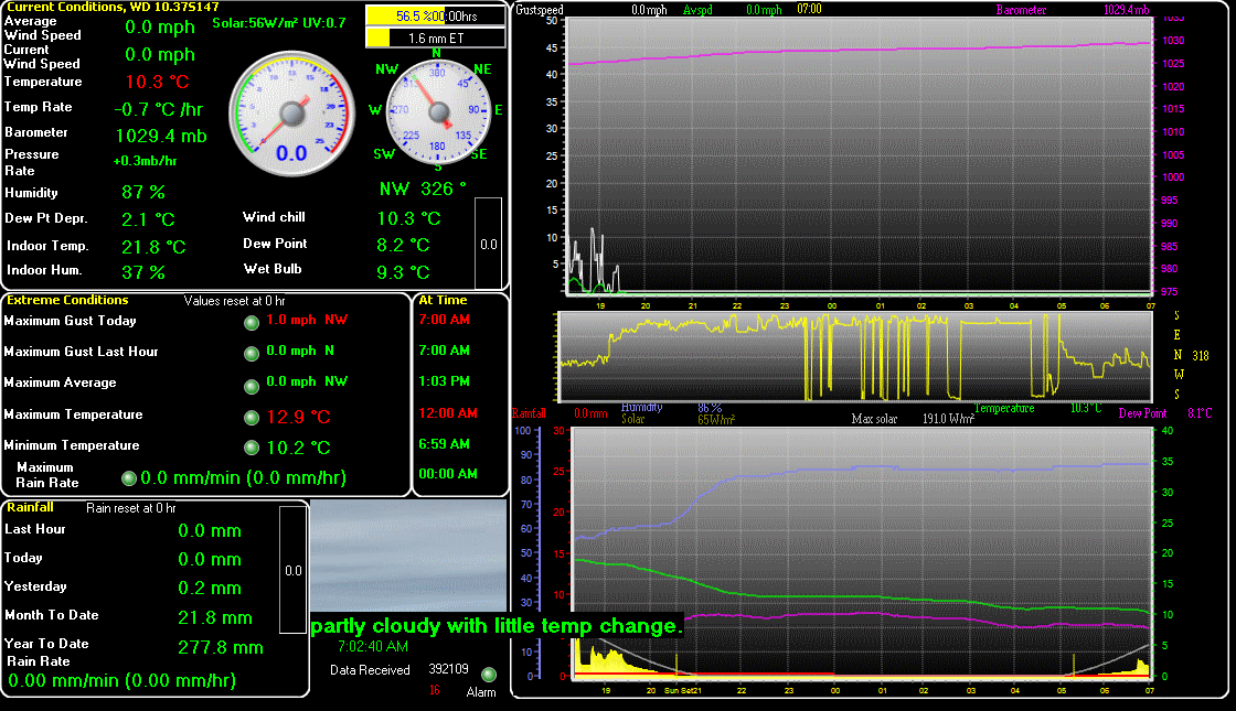
The temperature at 5.07pm was 15.2C, humidity 85%, and the barometric pressure 1005.3mb's and rising slightly
Top temperature today was 18.1C
Last gust was 26mph WSW
Rain for January was 88.2mm
Rain for February was 86.8
Rain for March was 25.4mm
Rain for April was only 2.8mm
Rain for May was16.0mm
Rain so far today is 5.8mm
Rain so far for June is 64.3mm
Rain year to date was 277.4mm
Rain for 2025 was 470.6mm which is below average for this area
Rain for 2024 was 676.7mm which was above average for this area
Rain for 2023 was 713.4mm which is high for this area
Rain for 2022 was 572.7mm which is average for this area.
Rain for 2021 was 642.9mm which is slightly above average for this area.
Rain for 2020 was 607.4mm which was about average for this area.
Rain for 2019 was 696.3mm which was above average
Rain for 2018 was 617.8mm which is slightly above average
Rain for 2017 was 707.7mm which is above average for this area.
Rain for 2016 was 586.7mm which is average for this area.
Rain for 2015 was 581.6mm which is average for SW Essex
Rain for 2014 was 881.4mm which is an all time record for this area..
Rain for 2013 was 727.2mm which is above average for SW Essex.
Rain for 2012 was 858.9mm which was high for this area.
Rain for 2011 was 417.5mm which is very low for this area which normally has around 525 to 575mm
Last updated at 5.07pm Saturday
Next update at 0645BST
